Vegetation seasonality, particularly in the tropical dry regions, can cause conventional land cover classification that rely on satellite data to "misclassify" land cover types, because a single satellite image might reflect only a particular stage within a natural phenological cycle. To address this, we developed a phenology-based synthesis (PBS) classification algorithm that maps land cover by analysing full time series, rather than temporal composites, of satellite images using the Google Earth Engine cloud computing platform. The PBS classifier operates through occurrence rules applied to a series of single date image classifications of a study area to assign the most appropriate land cover class. Since the launch of Landsat 8 in 2013, every point on Earth is imaged every 16 days with exceptional radiometric quality. By feeding Landsat 8 data to a PBS classifier, we mapped the land cover of four protected areas and their 20-km buffer zones in different ecoregions of Sub-Saharan Africa.
The Google Earth Engine script of the PBS classifier can be found at https://code.earthengine.google.com/fcc04d2a79aef5f123008d6c178a18c0 (for GEE trusted user only)
Validation of the maps through a visual interpretation of coincident very high resolution images and a web-GIS showed that the combined overall accuracy exceeded 90 %. The Sentinel 2 satellites will drastically increase the frequency of global image acquisitions, which, along with the Landsat 8 programme and open data policies, will enable near real-time monitoring of Earth's surface at a 10-30 m resolution. Using the first series of Sentinel 2a images over one of the test areas, we demonstrate that Landsat 8 and Sentinel 2 data streams can be jointly exploited by PBS classification to provide exceptional spatial and temporal detail for the mapping and monitoring of global land cover.
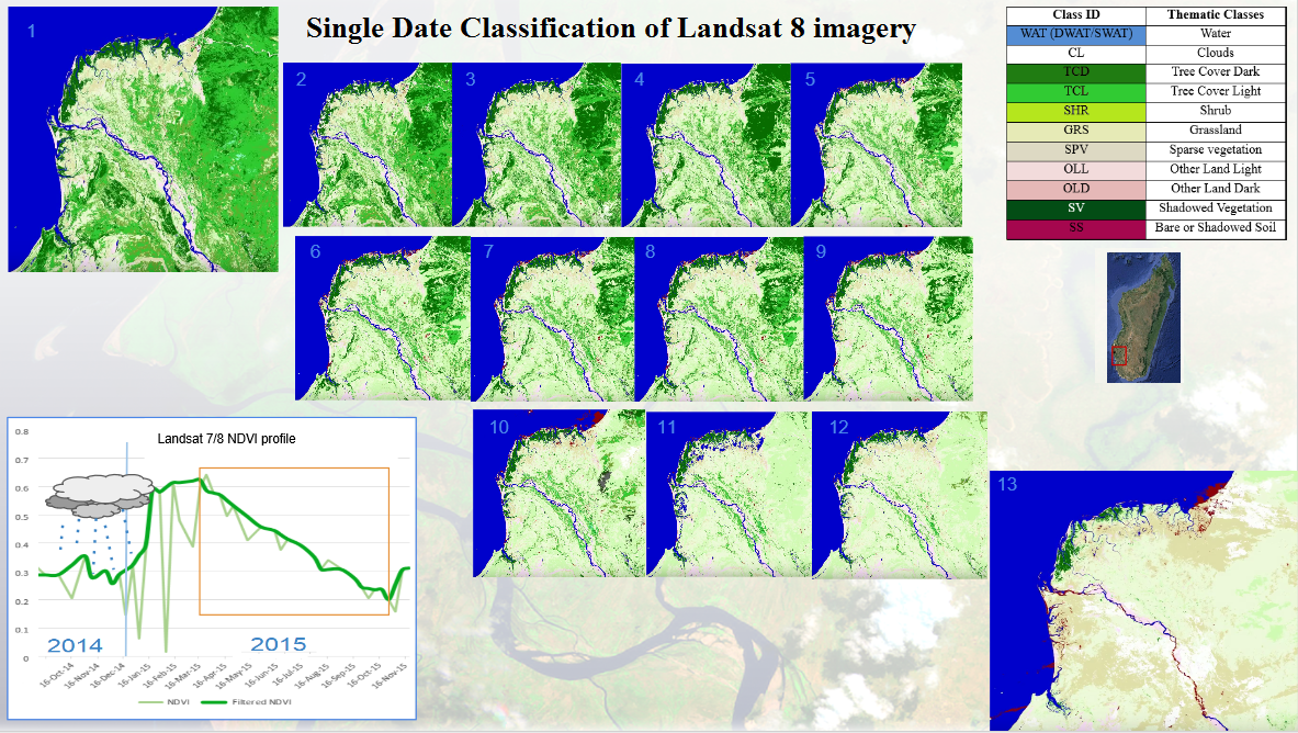 Single date classification of Landsat 8 imagery
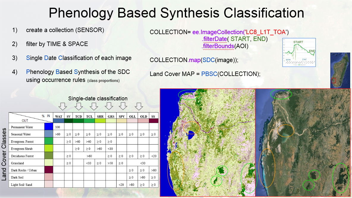 Phenology based synthesis classification
American Geophysical Union's Fall Meeting 2015 presentation download
Simonetti D., Simonetti E., Szantoi Z., Lupi A., and Eva H. D., 2015 First results from the phenology-based synthesis classifier using Landsat 8 imagery IEEE Geoscience and remote sensing letters https://publications.jrc.ec.europa.eu/repository/handle/JRC95065
Simonetti E., Simonetti D., Preatoni D., 2014 Phenology-based land cover classification using Landsat 8 time series Luxembourg: Publications Office of the European Union https://publications.jrc.ec.europa.eu/repository/handle/JRC91912
The JRC TREES-3 project aims at estimating forest cover changes at continental and regional levels for the tropical belt for the periods 1990-2000 and 2000-(2005)-2010 based on a systematic sample of forest cover change maps. An operational system has been developed for the processing and change assessment of a large data set of multi-temporal medium resolution imagery (sample units of 20 km x 20 km size analysed from with Landsat imagery). The main task is to assess as accurately as possible for each sample unit the forest cover and forest cover change between two dates.
The analysis includes a crucial final step of visual verification and final assignment of land cover labels which is carried out by forestry national officers or remote sensing experts from tropical countries. The visual interpretation is conducted interdependently on two-date imagery to verify and to adjust the labels pre-assigned to each segment for the different dates. A dedicated stand-alone application has been developed for this purpose. The application is a graphical user interface, called the JRC Land Cover Change Validation Tool. The aim of this tool is to provide a user-friendly interface, with an optimised set of commands to navigate through and assess a given dataset of satellite imagery and land cover maps, and to correct easily the land-cover labels as appropriate. FAO is collaborating with JRC in this work under the Global Forest Resource Assessment (FRA) Remote Sensing Survey. JRC has added functionality to the tool to enable labelling of land-use classes that are part of the FRA classification.
The technical document, entitled "User Manual for the JRC Land Cover/Use Change Validation Tool" describes the steps for the installation of the tool on a personal computer, as well as the detailed features of this dedicated graphical user interface. The authors welcome feedback from potential users of the tool, in particular reporting of any potential software issue or providing suggestions for improvements of future versions of the tool.
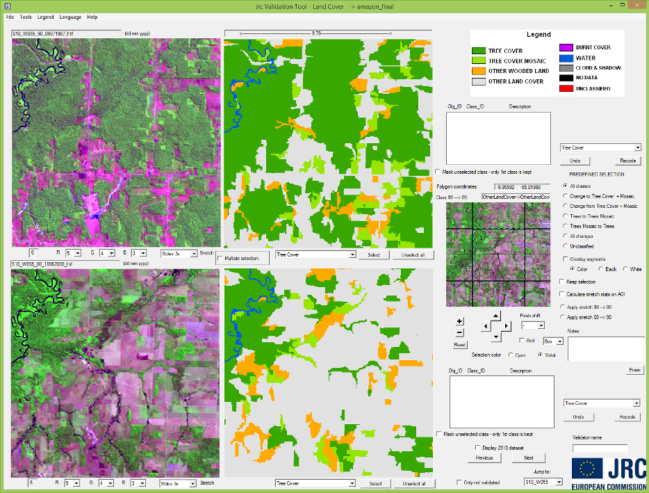
Simonetti D, Beuchle R, Eva HD, 2011 User Manual for the JRC Land Cover/Use Change Validation Tool Luxembourg: Publications Office of the European Union, EUR 24683 EN https://publications.jrc.ec.europa.eu/repository/handle/JRC62603
Achard F., Beuchle R., Mayaux P., Stibig H.-J., Bodart C., Brink A., Carboni S., Desclée B., Donnay F., Eva H.D., Lupi A., Raši R., Seliger R., Simonetti D., 2014 Determination of tropical deforestation rates and related carbon losses from 1990 to 2010 Global Change Biology (2014) 20, 2540-2554 https://onlinelibrary.wiley.com/doi/10.1111/gcb.12605/abstract
Bartalev S. S., Kissiyar O., Achard F., Bartalev S.A., Simonetti D., 2014 Assessment of forest cover of Russia by combining a wall to wall coarse resolution land cover map with a sample of 30m resolution forest maps Int. J. Remote Sens. 35 (7):2671-2692 https://dx.doi.org/10.1080/01431161.2014.883099
Beuchle R, Grecchi RC, Shimabukuro YE, Seliger R, Eva HD, Sano E, Achard F, 2015 Land cover changes in the Brazilian Cerrado and Caatinga biomes from 1990 to 2010 based on a systematic remote sensing sampling approach Applied Geography 58 (2015) 116-127 https://www.sciencedirect.com/science/article/pii/S0143622815000284
Bodart C, Brink A, Donnay F, Lupi A, Mayaux P, Achard F, 2013 Continental estimates of forest cover and forest cover changes in the dry ecosystems of Africa for the period 1990 - 2000 Journal of Biogeography (2013) 40, 1036-1047 https://onlinelibrary.wiley.com/doi/10.1111/jbi.12084/pdf
Eva H.D., Achard F., Beuchle R., De Miranda E., Carboni S., Seliger R., Vollmar M., Holler W., Oshiro O., Barrena V., Gallego J., 2012 Forest cover changes in tropical South and Central America from 1990 to 2005 and related carbon emissions and removals Remote Sens. 2012, 4, 1369-1391 https://www.mdpi.com/2072-4292/4/5/1369
Mayaux P., Pekel J.-F., Desclée B., Donnay F., Lupi A., Achard F., Clerici M., Bodart C., Nasi R., Belward A., 2013 State and evolution of the African rainforests between 1990 and 2010 Phil. Trans. R. Soc. B 368: 20120300. https://dx.doi.org/10.1098/rstb.2012.0300
Stibig, H.-J., Achard, F., Carboni, S., Raši, R., Miettinen J., 2014 Changes in tropical forest cover of Southeast Asia from 1990 to 2010 Biogeosciences. 11, 247-258 (2014) https://www.biogeosciences.net/11/247/2014/