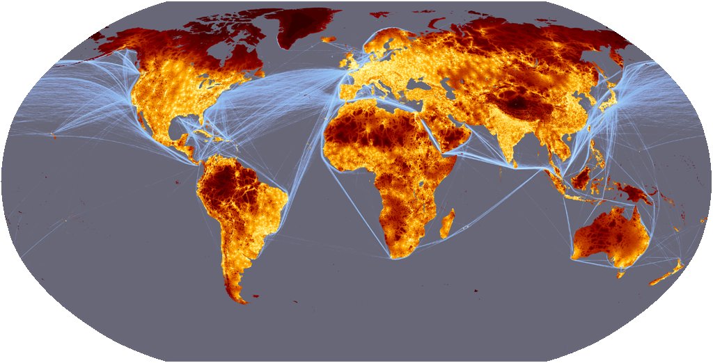

Travel time to major cities (in hours and days) and shipping lane density
New travel time map available: A new travel time map has been developed for 2015. These two maps were produced using different definitions of a city and thus cannot be used for assessing change through time
The world is shrinking. Cheap flights, large scale commercial shipping and expanding road networks all Wilderness? Only 10% of the land area is remote – more than 48 hours from a large city mean that we are better connected to everywhere else than ever before. But global travel and international trade and just two of the forces that have reshaped our world. A new map of Travel Time to Major Cities - developed by the European Commission and the World Bank - captures this connectivity and the concentration of economic activity and also highlights that there is little wilderness left. The map shows how accessible some parts of the world have become whilst other regions have remained isolated. Accessibility - whether it is to markets, schools, hospitals or water - is a precondition for the satisfaction of almost any economic need. Furthermore, accessibility is relevant at all levels, from local development to global trade and this map fills an important gap in our understanding of the spatial patterns of economic, physical and social connectivity.
These web pages describe the global map of accessibility, the input GIS data and a description of the underlying model that were developed by Andrew Nelson in the GEM unit in collaboration with the World Bank's Development Research Group between October 2007 and May 2008.
Accessibility maps are made for a specific purpose and they cannot be used as a generic dataset to represent "the" accessibility for a given study area. The data described and presented here were used to create an urban/rural population gradient around large cities of 50,000 or more people. The assumptions made in the generation of this accessibility map can be found in the description and data sources links on the left. If these assumptions sound reasonable for your requirements then the data are available for download. If, however, the assumptions do not match your requirements then you can use the information in these pages as well as the software and external links to create your own accessibility model.
This map was made for the World Bank's World Development Report 2009 Reshaping Economic Geography. The message of the report can be summarised as: Concentration & density. 95% of the people live on just 10% of the land "As economies grow from low to high income, production becomes more concentrated spatially. Some places—cities, coastal areas, and connected countries—are favored by producers. ... The way to get both the immediate benefits of concentration of production and the long-term benefits of a convergence in living standards is economic integration." (WDR 2009, Overview). For measuring the concentration of economic activity, instead of using binary distinctions of rural versus urban, the report takes advantage of global accessibility measures which can be combined with data on population density to create a much finer typology which is termed the Agglomeration Index (AI). The global map of travel time to major cities (cities of 50,000 or more people in year 2000) is a useful dataset in its own right, but it is also a component of the AI. This is described further in:
Uchida, H. and Nelson, A. Agglomeration Index: Towards a New Measure of Urban Concentration. Background paper for the World Bank’s World Development Report 2009.
Uchida, H. and Nelson, A. (accepted) Agglomeration Index: Towards a New Measure of Urban Concentration. In: Guha-Khasnobis, B. (Ed), Development in an Urban World, UNU-WIDER, pxxx-xxx.