At the end of 2004 Mrs. Rosalía Arteaga Serrano, Secretary-General of the Amazon Cooperation Treaty Organization (ACTO), asked the President of the European Commission for the scientific and technical support of the Commission’s Joint Research Centre (JRC) in defining the geographical boundaries of Amazonia.
The European Commission responded positively to the request from ACTO through a letter of JRC Acting Director General Roland Schenkel dated 22nd December 2004, offering the expertise of the Joint Research Centre.
The task is being coordinated by the JRC’s former Institute for Environment and Sustainability (IES) in Ispra (Italy). IES staff have been consulting with Latin American scientists and collecting available map and satellite data to support the work.
As part of the process, IES organised a two day workshop of selected European experts on Amazonia, held at the JRC Ispra site on the 7th and 8th of June, 2005. The experts came together to present current thinking on the geographical borders of Amazonia from different scientific perspectives, such as climate, hydrology, flora, fauna, ecology and biogeography. The invited experts represented a range of geographic areas and major research initiatives on Amazonia and included a number of former and current directors of major institutions active in the region.
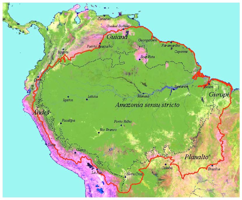
The result is shown below, where an Amazonia sensu latissimo (in red) gives the full extent of the delimitation. However, accepting the wide biogeographic and geomorphological differences, the region is divided into five subregions: one core subregion (Amazonia sensu stricto) and four peripheral: Andes, Planalto, Guiana and Gurupí. The Amazonia sensu stricto subregion is defined by the limit of the Amazon Basin in the north, the 700 m contour in the west and the lowland Amazon rainforest biome (before exploitation) in the south and south-east. The Andes subregion is from the 700 m altitudinal zone up to the watershed of the Amazon Basin. The Planalto subregion is the area between the Amazon lowland rainforest boundary and the limits of the Amazon/Tocantins headwaters in Bolivia and southern Brazil. The Guiana subregion is bound in the north by the Atlantic coast and the Orinoco and Vichada rivers, whereas the southern limit is formed by the watershed with the Amazon River Basin. The Gurupí subregion is located to the east, outside of the Amazon/Tocantins river basins, but is covered by the Amazon lowland rainforest, with limits defined by Soares (1953). The use of these five subregions (Amazonia sensu stricto, Andes, Planalto, Guiana and Gurupí) allows a flexibility that would be impossible with one sole region.
The geographical boundaries' Shapefile can be downloaded from here.
The related report is available in English, Spanish and Portuguese