The lead objective of the ReCaREDD project (Reinforcement of Capacities for REDD+) is to enhance the capacity of institutions in tropical partner countries to report on forest degradation, in a reliable and cost‐efficient manner. This project will use the best available science and knowledge to develop, jointly with partner countries, techniques for forest monitoring and to strengthen national capacities to report on REDD+ challenging activities, such as forest degradation and forest regrowth.
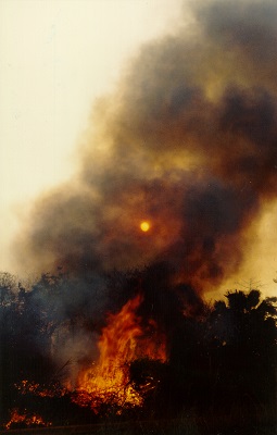 Forest fire in Brazil
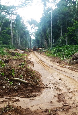 Logging road in Central Africa
The quantification of forest degradation is of key importance for many tropical countries that have deployed sustainable forest management practices on their territory. Not all kind of forest degradation can be detected by remote sensing methods. Optimal approaches and methodologies for monitoring forest degradation are likely to vary depending on the type and location of the degradation as well as of forest types concerned. The choice of method is also depending on the spatial resolution (typically varying between 1-30 m for degradation monitoring) and the temporal frequency of image acquisition of the specific satellite system.
The long-term objective of ReCaREDD is to improve the sustainable management of tropical forest resources in selected developing countries and ultimately to reduce the climate vulnerability of local populations.
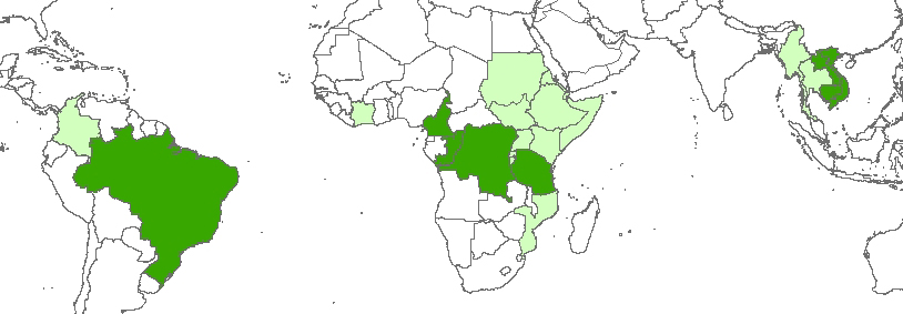 ReCaREDD focus countries (green) and associated countries (light green)
The ReCaREDD project carries out activities within the three tropical regions, namely Sub-Saharan Africa, Continental Southeast Asia and South America. In each of the regions methodologies are developed and tested with partners in selected countries ("focus countries") for the mapping and monitoring of disturbed/degraded forests through the use of remote sensing imagery, in particular from the recent Sentinel-2 satellite from the European Union Copernicus programme. Institutions from other tropical countries are welcomed to access methodologies and forest monitoring tools developed by the project, as well as to contribute and participate in workshops organized by the project ('Associated Countries').
The 'Focus countries' include:
Associated countries include presently: countries of the IGAD region (East Africa), Cote d'Ivoire, Moçambique, Colombia, Myanmar and Thailand.
The second pillar of the ReCaREDD project is the reinforcement of the OFAC, the regional Observatory of Forests in Central Africa, and the establishment of a prototype of regional forest observatories in East Africa and in continental Southeast Asia.
From a technical perspective, methods for extracting information related to tropical forest degradation from satellite imagery can be coarsely grouped into pixel based vs. segmentation based approaches, with varying levels of possible automation. Generally, regardless of the technical choices, the aim is to detect signs of degradation in the remotely sensed data utilizing various indicators. These indicators include e.g. gaps in the forest canopy, intensity of soil or senescent vegetation reflectance within forest area, fraction of forest canopy and variation of textural features between forest segments. The indicators may be analyzed either on a single remote sensing scene (image), or with change detection techniques taking advantage of a temporal series of satellite images. Finally, buffering approaches have been used in large scale studies taking advantage of road, village and waterway databases by assuming certain levels of degradation as a function of the distance to a given feature (e.g. road).
The main reasons for forest disturbances / forest degradation are: unsustainable selective logging, forest fires, firewood collection, charcoal production, shifting cultivation.
Forest fire in Mato Grosso State, Brazilian Amazon (Landsat 8, 30 m spatial resolution):
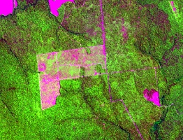 Deforested area — 30.08.2015
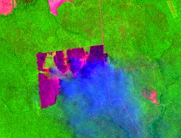 Burning of deforested area — 17.10.2015
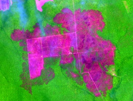 Fire 'escape' from burning deforested areas → forest fire — 4.12.2015
Selective logging and shifting cultivation (Sentinel-2 imagery, 10 m spatial resolution):
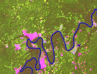 Shifting cultivation near Rio Inírida, Colombian Amazon, 2016
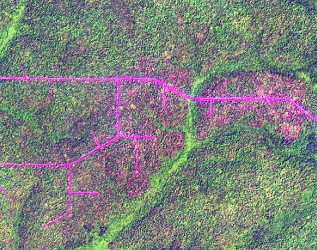 Selectively logged forest in Congo, 2016
Software development tailored to the mapping and monitoring of disturbed / degraded tropical forest, including (a.o.) tools for the Landsat, Sentinel-2 and RapidEye pre-processing, automatic land cover classification, linear un-mixing, segmentation and sampling layout planning.
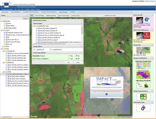 IMPACT toolbox - designed for the mapping of forest disturbances with medium to high resolution satellite imagery
Joint remote sensing - based methods development, together with national institutions, for national reporting of forest degradation in the context of REDD+:
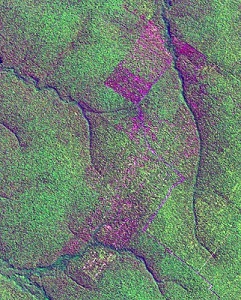 Selectively logged forest
in Mato Grosso, Brazil
on Landsat 7 image from 2003
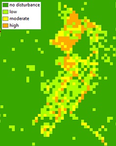 Disturbance severity mapping
with the soil fraction images
 Selectively logged forest in Cambodia
 Disturbance severity mapping
with normalized burn ratio images
using Landsat 8 image data
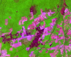 Burned areas in Mato Grosso
(Landsat 8 image from 19.10.2015)
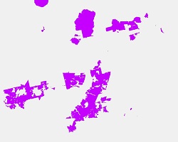 Mapping of burned forest
A method has been developed in collaboration with the Brazilian National Space institute (INPE) to map fire-induced forest degradation in Brazilian Amazon (Shimabukuro et al., 2015; Miettinen et al., 2016).
Further developments will focus on the throughout design of (sample-based or wall-to-wall) mapping of (sub-) national forest degradation (/disturbance) in the humid forest domain and the adaption of the methods to other forest types.
Langner A, Miettinen J, Kukkonen M, Vancutsem C, Simonetti D, Vieilledent G, Verhegghen A, Gallego J, Stibig H-J, 2018 Towards Operational Monitoring of Forest Canopy Disturbance in Evergreen Rain Forests: A Test Case in Continental Southeast Asia. Remote Sensing. 10, 4, 544, doi:10.3390/rs10040544 https://www.mdpi.com/2072-4292/10/4/544
Achard, F., Malheiros de Oliveira, Y.M. & Mollicone, D., 2017 Monitoring forest cover and deforestation In: J. Delincé (ed.), Handbook on Remote Sensing for Agricultural Statistics (Chapter 7). GSARS: Rome. https://gsars.org/wp-content/uploads/2017/09/GS-REMOTE-SENSING-HANDBOOK-FINAL-04.pdf
Grecchi R, Beuchle R, Shimabukuro Y E, Aragão L E, Arai E, Simonetti D, Achard F, 2017 An integrated remote sensing and GIS approach for monitoring areas affected by selective logging: a case study in northern Mato Grosso, Brazilian Amazon Int J Appl Earth Obs Geoinformation 61 (2017) 70–80 https://www.sciencedirect.com/science/article/pii/S0303243417300971
Simonetti D., Marelli A., Rodriguez D., Vasilev V., Strobl P., Burger A., Soille P., Achard F., Eva H., Stibig H.J., Beuchle R., 2017 Sentinel-2 web platform for REDD+ monitoring, online web platform JRC Technical Report, European Commission, 2017. EUR 28658
Verhegghen A, Eva HD, Desclée B, Achard F, 2016 Review of recent forest cover and forest cover change assessments in Cameroon International Forestry Review 18(2), 1-12 https://www.ingentaconnect.com/contentone/cfa/ifr/2016/00000018/A00101s1/art00003
Verhegghen A, H. Eva, G. Ceccherini, F. Achard, V. Gond, S. Gourlet, P.O. Cerutti, 2016 Forest fire detection and monitoring potential by Sentinel satellites assessed in the Congo Basin Remote Sensing 8 (12), 986 https://www.mdpi.com/2072-4292/8/12/986
Miettinen J, Shimabukuro YE, Beuchle R, Grecchi RC, Velasco-Gomez DM, Simonetti D, Achard F On the extent of fire-induced forest degradation in Mato Grosso, Brazilian Amazon, in 2000, 2005 and 2010 International Journal of Wildland Fire, 2016, 25, 129-136 https://www.publish.csiro.au/?paper=WF15036
Shimabukuro YE, Miettinen J, Beuchle R, Grecchi RC, Simonetti D, Achard F Estimating burned area in Mato Grosso, Brazilian Amazon, using an object-based classification method on a systematic sample of medium resolution satellite images IEEE Journal of Selected Topics in Applied Earth Observations and Remote Sensing, 2015, 8(9), 4502-4508 https://ieeexplore.ieee.org/stamp/stamp.jsp?arnumber=7219374
Miettinen, J., Stibig, H.-J., Achard, F., Hagolle, O. and Huc, M., 2015 First assessment on the potential of Sentinel-2 data for land area monitoring in Southeast Asian conditions. Asian Journal of Geoinformatics 15: (1) 23-30. https://www.geoinfo.ait.ac.th/ajg/index.php/journal/article/view/174
Shimabukuro YE, Beuchle R, Grecchi RC, Achard F Assessment of forest degradation in Brazilian Amazon due to selective logging and fires using time series of fraction images derived from Landsat ETM+ images Remote Sensing Letters, 2014, 5(9), 773-782 https://www.tandfonline.com/doi/full/10.1080/2150704X.2014.967880
Langner A, Achard F, Grassi G, 2015 Can recent pan-tropical biomass maps be used to derive alternative Tier 1 values for reporting REDD+ activities under UNFCCC? Environ. Res. Lett. 9 (2014) 124008 (12pp) https://iopscience.iop.org/1748-9326/9/12/124008
Miettinen J, Stibig H-J., Achard F, 2014 Remote sensing of forest degradation in Southeast Asia - aiming for a regional view through 5-30 m satellite data Global Ecology and Conservation 2 (2014) 24–36 https://dx.doi.org/10.1016/j.gecco.2014.07.007