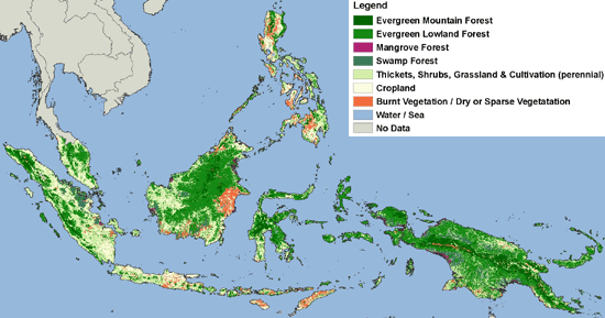
The 'Forest Cover Map of Insular Southeast Asia' covers the countries of Malaysia, Singapore, Indonesia, Brunei, East Timor and the Philippines. The map also includes Papua New Guinea. This map was produced by digital classification of a regional SPOT VEGETATION satellite image composite, based on the acquisitions of two years (March 1998 – March 2000). The spatial resolution of the map corresponds to about one square kilometre (112º -1).

The 'Forest Cover Map of Insular Southeast Asia' displays the main forest formations of the region, including evergreen mountain forest (> 1000m elevation), evergreen lowland forest (< 1000m elevation), mangrove forests and swamp forests. The few seasonal forests in the far south of Sulawesi and New Guinea, and on the Philippines were not mapped as separate class. Forest cover on this map may include degraded forest cover as well as mature stages of forest regrowth. The mixed patterns of bush, thickets, grassland and perennial cropland, including oil palm and rubber plantation, had to be grouped in one class, whilst the class ‘cropland’ refers mainly to annual crops. The burnt areas in the lowland of Sumatra and Borneo, a result of the fires in 1997 and 1998, were well depicted. However, due to spectral similarity on the satellite image composite, these areas were included in one class, together with dry vegetation (other islands) and sparse grassland and rocks at high altitudes (e.g. > 3000 m on New Guinea).
For accessing digital data see the download section (top left of page)
A cartographically elaborated (printed) version is available: TREES_insularSEA_map_fullres2.jpg (6 MB)
For more information on this topic, or for ordering a paper version of the map, please contact Hans-Jürgen Stibig
Mapping of the tropical forest cover of insular Southeast Asia from SPOT4-Vegetation images, Stibig, H-J., Beuchle, R. and F. Achard, 2003. International Journal of Remote Sensing, 24(18), 3651-3662.
Forest cover of insular southeast Asia mapped from recent satellite images of coarse spatial resolution, Stibig, H-J. and Malingreau, J.P. 2003, Ambio, 32(7), 469-475.
Forest cover map of insular Southeast Asia at 1:5 500 000 Stibig, H-J., Beuchle, R, and Janvier, P. 2002, Publications of the European Communities, EUR 20129 EN, European Commission, Luxembourg.
| Forest Cover of Insular Southeast Asia | metadata |
Forest cover map of insular Southeast Asia at 1:5,500,000. Stibig, H-J., Beuchle, R, and Janvier, P. 2002, Publications of the European Communities, EUR 20129 EN, European Commission, Luxembourg. 20 pp.
Mapping of the tropical forest cover of insular Southeast Asia from SPOT4-Vegetation images, Stibig, H-J., Beuchle, R. and F. Achard, 2003. International Journal of Remote Sensing, 24(18), 3651-3662.