The Global vegetation Monitoring Unit carries out several activities related to Land Cover mapping and monitoring.
In particular the GVM Unit is coordinating and implementing the Global Land Cover 2000 Project (GLC 2000) in collaboration with a network of partners around the world.
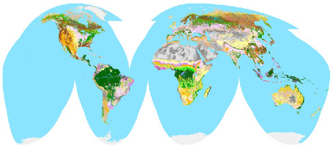
The general objective is to provide for the year 2000 a harmonized land cover database over the whole globe. The year Two Thousand is considered as a reference year for environmental assessment in relation to various activities, in particular the United Nation's Ecosystem-related International Conventions.
To achieve this objective GLC 2000 makes use of the VEGA 2000 dataset: a dataset of 14 months of pre-processed daily global data acquired by the VEGETATION instrument on board the SPOT 4 satellite, made available through a sponsorship from members of the VEGETATION programme, including JRC.
On June 3rd, 2002, Dr. Reid, Director of the Millennium Ecosystem Assessment has informed us that
We have now released data for all regional windows of the world, as well as the global landcover classification. These datasets are now available for download in various formats, both at full resolution, and in the form of a poster. In order to gain access to this part of the site, please provide us with some general information about yourself.
The following regional windows are available for download:
| South America | France |
| Africa | China |
| Northern Eurasia | North America |
| Asia | Solomon Islands |
| South Asia | Australia |
| South and South East Asia | New Caledonia and Vanuatu |
| South East Asia | New Zealand |
| Europe All | Fijian Islands |
| North East Europe | Greenland and Iceland |
| North West Europe | Hawaii |
| Southern Europe |
Our data is available free of charge for non-commercial use, provided it is properly referenced (see the copyright note).
There are 2 types of product:
The GLC2000 digital database, in its entirety, should be referenced as follows:
Global Land Cover 2000 database. European Commission, Joint Research Centre, 2003.
The exact quotation for each individual product (global and regional), can be found together with the digital product, on the data download page.
For redistribution of part or the totality of the GLC 2000 database, e.g. in web sites and for commercial applications, please read our disclaimer and copyright notice.
Product accuracy will be defined using a statistical sampling procedure. This operation is still in progress. Information will be provided as soon as it becomes available. See the disclaimer note.
Please consult the metadata of each product for more information.
The GLC2000 project uses the FAO Land Cover Classification System (LCCS). This is a hierarchical classification, which allowed each regional partner to describe the landcover classes at the thematic detail best suited to the landcover in their region of expertise, whilst following a standardised classification approach.
Furthermore, the LCCS allowed the regionally defined legends to be translated into more generalised global landcover classes for the GLC2000 global product. These global classes describe the type of vegetation and the density of the cover, independent of geo-climatic zone, such as temperate or tropical forests.
The mosaicing of 21 regional products, and the translation to a standardised global legend, made it possible to create a consistent global landcover classification based on regional expert knowledge.
A short description of the GLC2000 global legend is available.
For a detailed description of the legend, using the LCCS software, we have also made available for download the LCCS list of classifiers and the LCCS standard class description. The GLC2000 legend, along with the LCCS codes for each global class is also available in either *.htm, *.txt or *.xls formats for importing into the LCCS software#.
For further information regarding the GLC2000 legend, please contactHans-Jurgen Stibig.
For further information regarding the LCCS, please contact john.latham@fao.org.
# Please neglect the 'error' message in the first column of these files. It is a small error
in the export of the legend, and does not affect the use of the legend within the LCCS software.
| Achard F. (JRC) | Data classification: state of the art of current practices & methods (.pdf file, 22KB) |
| Achard, F. (JRC) | Objectives of the workshop on methods (0.6 MB) |
| Agrawal Shefali (IIRS) | Phenology based Classification Model for Vegetation Mapping using IRS-WiFS (2.1 MB) |
| Agrawal S., Joshi P.K., Shukla Y., Roy P.S. (IIRS) | SPOT4-Vegetation multi temporal data for classifying vegetation in South Central Asia. (pdf 40 Kb) |
| Barnsley M. ( Wales Univ) | Estimation of land surface albedo and vegetation biophysical properties using SPOT-4 VGT and semi-empirical BRDF models. (4.0 MB) |
| Bartalev, S. ( IFI Moscow & JRC) | Russia land cover mapping from VGT S-10 data (4.0 MB) |
| Bartalev, S. & al. ( IFI Moscow & JRC) | land cover mapping of Eurasia's boreal ecosystems (March 2002) (10.5 MB) |
| Bartalev S., Erchov D., Isaev A., Belward A. (CFEP RAS, and JRC) | The land cover of Northern Eurasia: Method, product, and initial users feedback. March 2003. (21.5Mb) |
| Bartalev S., Egorov V., Bartholomé E. (CFEP RAS, and JRC) | Landcover mapping of Iceland and southern Greenland. March 2003. (2.13Mb) |
| Bartalev S., Erchov D., Isaev A., Belward A. (CFEP RAS, and JRC) | A new SPOT4-Vegetation derived land cover map of Northern Eurasia. Int. J. Remote Sensing, 2003, Vol. 24, No. 9, 1977-1982. (pdf 0.2 Mb) |
| Bartholomé E. (JRC) | GLC 2000: current status of network development (.pps file, 1885 KB) - (Nov. 2000) |
| Bartholomé E. (JRC) | VEGETATION data for GLC 2000: properties of the VEGA 2000 data set (.pps file, 6019 KB) |
| Bartholomé E. (JRC) | Status of GLC 2000 project implementation - March 2001 (1.5MB) |
| Bartholomé E. & al | GLC 2000 Europe window: status of partnership & first results (March 2002) (0.2 MB) |
| Bartholomé E. & Cherlet M (JRC & FAO) | GLC 2000 land cover map of the desert locust recession area - first results (March 2002) (7.6 MB) |
| Bartholomé & al. | rescaling VEGETATION NDVI into apparent fractional cover for dryland studies (March 2002) (4.3 MB) |
| Bartholomé E., Belward A. S., Achard F., Bartalev S., Carmona Moreno C., Eva H., Fritz S., Grégoire J.-M., Mayaux P., Stibig H.-J. | Global Land Cover mapping for the year
2000 - Project status November 2002 (ref EUR 20524) (pdf,
1.5MB) |
| Bartholomé E. (JRC) | Land cover mapping at global scale: some lessons learnt from the GLC2000 project. March 2003. (384Kb) |
| Belward A. S. (JRC) | Introduction to the "legend" workshop |
| Belward A. S. (JRC) | Synthesis and conclusions of the "legend" workshop" |
| Belward A. S. & al (JRC) | GLC 2000 "first products" workshop: project overview - March 2002 (0.9 MB) |
| Cabral A. & al (Trop. Res. Inst. Lisbon) | spectral separability of land cover classes in Southern Africa - an application of LCCS (March 2002) (3.6 MB) |
| Cabral A. & al (Trop. Res. Inst. Lisbon) | multitemporal compositing approaches for SPOT4-VEGETATION data (March 2002) (8.5 MB) |
| Cabral A., de Vasconcelos M., Pereira J., Bartholomé E., Mayaux P. | Land cover map of southern hemisphere Africa using SPOT-4 Vegetation data. March 2003. (5.10Mb) |
| Carmona C. (JRC) | managing and documenting th GLC 2000 products (March 2002) (1.2 MB) |
| Champeaux, J.-L. (Meteo-France) | Preliminary tests on Vegetation data over France (1 MB) |
| Champeaux, J.-L. (Meteo-France) | correction of bi-directional effects and impact on land voer classifications (March 2002) (1.7 MB) |
| Champeaux, J.-L. & Garrigues (Meteo-France) | land cover mapping project over France using S1-S10 SPOT-4/VEGETATION data (March 2002) (0.5 MB) |
| Champeaux J-L., Masson V., Chauvin F. | ECOCLIMAP: A global database of land surface parameters at 1km resolution. March 2003. (1.03Mb) |
| Champeaux J-L., Han K-S. | Landcover map of France using SPOT Vegetation S1 / S10 data. March 2003. (9.03Mb) |
| Cherlet M. (JRC) | Mapping of arid regions in Africa using VGT S-10 data part1 = 4.8 MB part 2 = 4.7 MB |
| De Badts E. | GLC2000 British Isles and Northwest Europe: An evaluation of the SPOT Vegetation sensor for land use mapping. March 2003 (15 Mb) |
| Defourny, P. (UCL - Louvain-la-Neuve) | Mapping of semi-Arid regions: case study of West Africa (9.6 MB) |
| Defourny, P. & al. (UCL - Louvain-la-Neuve) | mappimg of CILSS countries from daily VEGETATION data (March 2002) (not yet available) |
| Di Gregorio A. (AFRICOVER) | the FAO Land Cover Classification Scheme: how it works (.pps file, 676KB) |
| Eerens, H. (VITO - Mol) | Data reduction and enhancement of global composites of SPOT- VGT (1.3 MB) |
| Eva, H. (JRC) | Minutes of the GLC 2000 Kick-off meeting - May 2000 |
| Eva, H. (JRC) | Introduction to bi-directional and mosaics effects: comparison with the ATSR sensor (4.8 MB) |
| Eva, H. & al. (JRC) | GLC 2000 South America map (March 2002) (3.2 MB) |
| Eva, H. & al (JRC) | A vegetation map of South America. March 2003 (5.6Mb). |
| Eva, H. & al (JRC) | A vegetation map of South America. 2002. EUR 20159 EN (pdf 1.66 Mb) |
| Fillol E. (JRC & Sherbrooke Univ.) | Test of forest classification over Bavaria (Germany) using a SPOT-VGT mosaic (5.7 MB) |
| Fritz S., & al (JRC) | Harmonisation, mosaicing and production of the Global Land Cover 2000 database (beta version). EUR 20849 EN. 2003 (1.92 Mb). Version 1 update (7 Kb). |
| Fritz S. (JRC) | Towards a global Land Cover 2000 product: the preliminary version of the global product and how it can be improved. March 2003 (3.25 Mb) |
| Giri C. & al. (CIESIN) | continental SE Asia (March 2002) (9.3 MB) |
| Giri C., Zhu Z. (EROS Data Center, USGS) | GLC2000 North America: Classification and Results Validation. March 2003 (1.62Mb) |
| Gond V. (CIRAD-Kourou) | Eastern Guiana shield land cover classification using SPOT-4/VEGETATION instrument (March 2002) ( 31.5 MB) |
| Grégoire, J.-M. (JRC) | Global Burned Area Product: methodological approach (0.6 MB) |
| Grégoire, J.-M. & al. (JRC) |
The Global Burnt Area 2000 initiative: GBA-2000 Mapping, from SPOT-VEGETATION S1 imagery, of the areas burnt globally during the year 2000 (March 2002) (1.5 MB) |
| Grégoire J-M., Tansey K., & al (JRC) | The Global Burnt Area 2000 initiative: GBA-2000 Final Results (1.65 Mb) |
| Guenther K. (DLR) | Land use / land cover classification using MOS data for preparing operational products of MERIS - Lepublications/workshop/method/a href="/data/products/glc2000/publications/workshop/method/guenther_dlr.pps">3.9 MB) |
| Hartley A. (JRC) | GLC2000 product availability via the GLC2000 website. March 2003 (0.5 Mb) |
| Jeanjean, H. (CNES) | Status of the VEGA 2000 inititative of the VEGETATION Programme (0.3 MB) |
| Jeanjean, H. (CNES) | European forest map prototype (8.3 MB) |
| Jeanjean, H. (CNES) | the VEGETATION data distribution policy modalities (March 2002) (0.9 MB) |
| Latham J. (FAO) | the FAO Land Cover Classification Scheme: Basic concepts (.pps file, 591KB) |
| Latham J. , Jansen L., Di Gregorio A. (FAO) | LCCS: a guide to utilization of concepts and software applications (.pps file, 11.5 MB) |
| Latifovic, R. (CCRS) | Processing the coarse resolution raw satellite measurement into land cover information. (28.6 MB) |
| Latifovic, R. (CCRS) | Global land cover mapping - North America window (March 2002) (5.7 MB) |
| Latifovic R. (CCRS) | GLC2000 Land cover database of North America. March 2003 (6.46Mb) |
| Latifovic R. and Giri C. (CCRS and USGS) | Landcover database of North America. 2002 (pdf 0.2 Mb) |
| Ledwith M. & al. (METRIA Stokholm) | classification of the Baltic Sea basin (March 2002) (0.6 MB) |
| Ledwith M. (Metria, Stokholm) | Mapping the Baltic sea basin. March 2003 (4.21 Mb) |
| Lima V. (JRC) | Image2000 and CORINE Land Cover 2000: A link between local and global land cover. March 2003 (1.84 Mb) |
| Lobo, A. (CSIC-Barcelona) | Methods for GLC2000: Thoughts and caveats from previous experiences (1.8 MB) |
| Mayaux, P. (JRC) | Forest cover map of Madagascar derived from SPOT VGT data (5.2 MB) |
| Mayaux, P. & Massart M. (JRC) | Africa: an overview (March 2002) (3 MB) |
| Mayaux, P. & al. (JRC) | A qualitative accuracy assessment (March 2002) (0.7 MB) |
| Mayaux P. & al (JRC) | The land cover of Africa for the year 2000. March 2003 (2.84 Mb) |
| Mayaux P. (JRC) | Validation of the GLC2000 products. March 2003 (3.91Mb) |
| Mayaux P. & al (JRC) | A land cover map of Africa; Carte de l'occupation du sol de l'Afrique. 2003. EUR 20665 EN (pdf 3.04 Mb) |
| de Miranda E.E., Guimarães M., Gomes E.G., Dorado A.J. | A comparison between GLC2000 results and Brazilian census data. March 2003 (1.23 Mb) |
| Mubareka, S. ( JRC & Sherbrooke U) | Optimisation of mosaicking techniques of VGT data for vegetation mapping in South East Asia (11.6 MB) |
| Mucher, S. (ALTERRA - Wageningen) | Pan-European Land Cover Mapping: the PELCOM project (2.7MB) |
| Mucher, C.A., and de Badts, E.P.J. (ALTERRA - Wageningen) | Global Land Cover 2000: Evaluation of the SPOT VEGTATION sensor for land use mapping. Wageningen, Alterra, Green World Research pp 49. 2002 (pdf 1.34 Mb) |
| Pekel J.-F. & al (UCL - Louvain-la-Neuve) | mapping of the African Great Lakes region from daily VEGETATION data (March 2002) (9.5 MB) |
| Pini G. | Improvement of EWS Products by land cover data. March 2003. (1.52Mb) |
| Pottier D. (Eur. Commission) | The international cooperation in the 6th framework programme for research and development (March 2002) (0.9 MB) |
| Saint, G. (CNES) | Development of new products for the VEGETATION sensor: the way forward (4.6 MB) |
| Saint, G. (CNES) | news form the VEGETATION project (March 2002) (1.8 MB) |
| Stibig H. J. (JRC) | Legend vs. classification scheme: the challenge for GLC 2000 (.pps file, 931KB) |
| Stibig H. J. (JRC) | recommendations: the GLC 2000 LCCS Minimum Legend, (.pps file,1.2 MB ) H. J: Stibig |
| Stibig H. J. (JRC) | Results of the workshop on legend held on 29 & 30 November 2000 (1.1 MB) |
| Stibig H. J. (JRC) | Regional assessment of Tropical forest cover in Southeast Asia using SPOT-VGT mosaics (4.6 MB) |
| Stibig H. J. (JRC) | LCCS output: Land cover Classification Legend - an example (short version - .pdf file, 132 KB) |
| Stibig H. J. (JRC) | LCCS output: Land cover Classification Legend - an example (standard version .pdf file, 208 KB) |
| Stibig H. J. (JRC) | List of land cover classifiers used (pdf file, 68 KB) |
| Stibig H. J. (JRC) | Asia: an overview, insular SE Asia (March 2002) (5.3 MB) |
| Stibig H. J. (JRC) | the GLC 2000 LCCS 1st global level scheme (March 2002) (0.7 MB) |
| Stibig H. J. (JRC) | GLC2000 Land cover classification. March 2003 (0.7 Mb) |
| Stibig H.J., Upik R.W., Beuchle R., Mubarek S., Hildanus, Giri C. | GLC2000: Results from Southeast Asia. March 2003 (10.5 Mb) |
| Stibig, H-J. and Malingreau, J.P. | Forest cover of insular southeast Asia mapped from recent satellite images of coarse spatial resolution. Ambio, 32(7), 469-475. (pdf 0.4 Mb) |
| Strahler A. (Boston U.) | The MODIS land cover product (March 2002) (13.3 MB) |
| Strahler A. (Boston U.) | Global land cover: approaches to validation (0.1 MB) |
| Swinnen, E. (VITO - Mol) | Fuzzy classification for sub-pixel land cover estimation (6.7 MB) |
| Tansey, M. (JRC) | GBA 2000 masking algorithms for SPOT VGT S products (1.4 MB) |
| Tateishi, R. (CEReS - Chiba U.) | Experiences of land cover mapping of Asia (not available on-line) |
| Tateishi, R. & al. (CEReS - Chiba U.) | Land cover mapping of Asia, Central Asia and Middle East for GLC 2000 project (March 2002) (0.5 MB) |
| Tateishi, R. (CEReS - Chiba U.) | Proposal for the Global Land Cover Ground Truth (GLCGT) database (March 2002) (0.3 MB) |
| Tateishi R., Sato H., Lin Z. (CEReS - Chiba U.) | Production of land cover map of Asia, Central Asia and Middle East with emphasis on the development of a ground truth database. March 2003 (0.6 Mb) |
| Van Cutsem, C. ( UCL - Louvain-la-Neuve) | Sensitivity analysis of compositing strategies: modeling and experimental investigations (9.2 MB) |
| Van Cutsem, C. & al. ( UCL - Louvain-la-Neuve) | Processing methodology for full exploitation of daily VEGETATION data (March 2002) (11.6 MB) |
| Viau A. (CRG. U. Laval) | not available |
| Waller, (E. USGS) | Observations From a Global Tree Cover Mapping Project: BRDF Effects and Implications for VEGETATION Compositing (3.1 MB) |
| Wu B. (IRSA - Beijing) | Crop area estimation with remote sensing (not available on-line)) |
| Wu B. & al. (IRSA - Beijing) | The GLC 2000 land cover map of China (March 2002) ( 4.3 MB) |
| Xiao X. (U. New Hamps.) | Sub-pixel mapping of cropland in China: using multi-temporal VGT data and spectral mixture analysis (6.8 MB) |
| Zhu, Z. (USGS) | Global land cover project at the USGS/EROS Data Center (1.1 MB) |