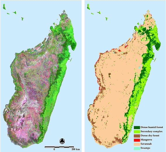
A forest-cover classification was derived from the 12 monthly composite VEGETATION images from November 1998 to October 1999. Five classes were mapped: dense humid forest (lowland and montane), dense dry forest, mangrove, secondary complex and savannah (woody savannah, grasslands and bare soil). The accuracy of the resulting map was assessed by comparison with Landsat classifications interpreted by local experts over three sites.
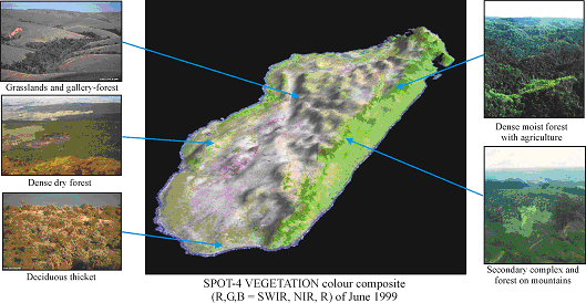
The forest-cover map illustrates the spatial distribution of the vegetation types analysed in the previous section: (i) the eastern moist region with dense humid forest mostly converted into a secondary complex in the lowland part and limited to the mountains, and (ii) the western drier region, nearly entirely covered by grassland, savannah and agriculture, with some patches of dense dry forest.
The accuracy assessment shows a high correspondence of the VEGETATION-derived map with Landsat TM classifications validated on the field. The user’s accuracy for the ‘dense humid forest’, which is our main class of interest, is 87.8%, with a producer’s accuracy of 85.6%.
For more information on this topic, or for ordering a paper version of the map, please contact Philippe Mayaux
A near real-time forest cover map of Madagascar derived from SPOT VEGETATION data, Mayaux P., V. Gond and E. Bartholomé, 2000. International Journal of Remote Sensing, 21/16:3139-3144.
| Forest Cover Map of Madagascar | metadata |
A near real-time forest cover map of Madagascar derived from SPOT VEGETATION data, Mayaux P., V. Gond and E. Bartholomé, 2000. International Journal of Remote Sensing, 21/16:3139-3144.