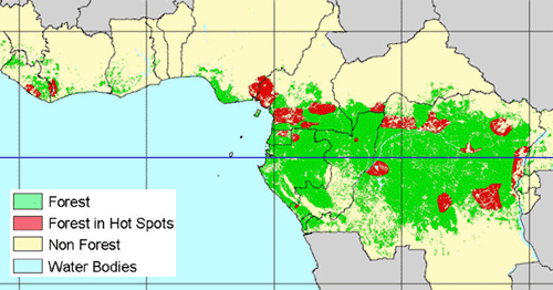
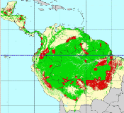
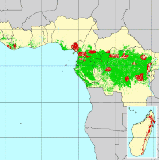
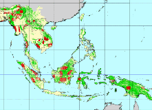
A group of experts met at the JRC in 1997 at the invitation of the TREES project to collectively identify areas of current and potential deforestation in the moist zone of the tropical belt. This approach of assessing deforestation was rather unconventional (in the sense that it does not directly lead to quantification) but was deemed important for the progress of the TREES project work-plan.
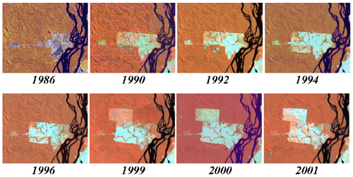
The group of experts coming from Europe and from the three concerned continents was of high level and very knowledgeable about deforestation processes. The basic task of the group was to locate on a map, areas of current or impending deforestation and to characterise the main drivers. The evidence on which the areas were designated was based on the personal experiences of the participants, with the understanding that the information upon which it is based will be subject to continuing revision.
The picture, which emerged at the end of the analysis conducted during the “hot spot” meeting, is a relatively bleak one. The information presented on these maps is cause for concern because it seems to indicate that the processes are steam rolling over large areas and may be irreversible.
For more information on this topic, or for ordering a paper version of the map, please contact Frédéric Achard
Identification of deforestation hot spot areas in the humid tropics, Achard F., Eva H., Glinni A., Mayaux P., Richards T. and Stibig H.J. 1998, TREES Series B, N°4, EUR 18079 EN, European Commission, Luxembourg, 100p.
A Synthesis on Rapid Land-Cover Change Information for the Period 1981-2000 Lepers E., E. F. Lambin, A. C. Janetos, R. DeFries, F. Achard, N. Ramankutty and R. J. Scholes 2005, Bioscience, 55:115-124
| Global Tropical Deforestation Hotspots | metadata |
Identification of deforestation hot spot areas in the humid tropics, Achard F., Eva H., Glinni A., Mayaux P., Richards T. and Stibig H.J. 1998, EUR 18079 EN, European Commission, Luxembourg, 100p.